Martha Sue Batt, Indianapolis, IN
msbatt@aol.com
Page 1
Picture #1

Picture #1 - Introduction: In October my husband,
daughter and I had the opportunity to spend most of a day in
the area of the Surb River in Switzerland about a half hour drive
northwest of the Zurich airport. It was a fascinating adventure
to see the area and to try to imagine what it was like when our
Surber ancestors lived there before coming to America in 1735.
Thanks go to George Riggins who let me know we had Swiss ancestors, to Elvina Hiatt for an e-mail crash course in Surber history, and to Carol Surber Lewis and other researchers. Carol's fascinating report of her 1998 trip whetted our appetite to see this area and helped us know how best to use our time there.
The following report provides no new genealogical data, as Carol's report did. This is simply a 24-photo tour of the area to show how it looks today and how some of it looked when our ancestors left it. Many of the buildings standing today were there before 1735, and much of the area is still open farmland as it was 300 years ago. Hope you will enjoy this view of the land of our Surber ancestors and cousins.
Bill, Susan and I drove first to Regensberg, this picturesque, storybook town on a hill. The castle tower in the picture has been prominent in the landscape since at least 1443, so our ancestors would have been familiar with it. Many of the homes also had plaques dating them before 1735, the year Hans Heinrich Surber Sr.(Old Henry) sailed to America with his wife and three children.
Picture #2
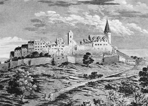
Picture #2 - This print shows the north side of Regensberg around 1720, the year Young Henry was born, just 15 years before our ancestors left the area. Then the castle tower had an enclosed turret. The picture is from page 49 of a history book in German that I found in Dielsdorf - "Regensberg" by Heinrich Hedinger, published by Verlag Paul Haupt in Bern, 1969.
Picture #3
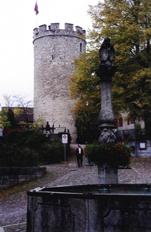
Picture #3 - The tower stands on the highest point of the highest hill in the region. The hill is surrounded by rolling and flat farmlands dotted with small towns. In feudal times and later, Regensberg was the center of municipal government for the region. Most residents of the area would farm and live in the villages around Regensberg. If they were threatened with attack, they would climb to the security of the castle on the high ground. From there, they would defend themselves.
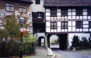
Picture #4
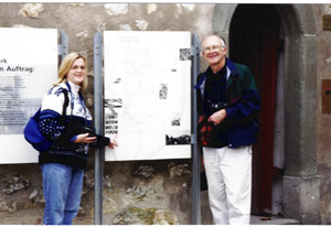
Picture #4 shows daughter Susan and husband Bill standing by a sign at the base of the tower. In the lower left corner of the sign are sixteen Regensberger Burgerwappen (wappen = crests, burger = citizens, regen = rain, berg = mountain). The Surber crest is the bottom right crest.
Picture #5
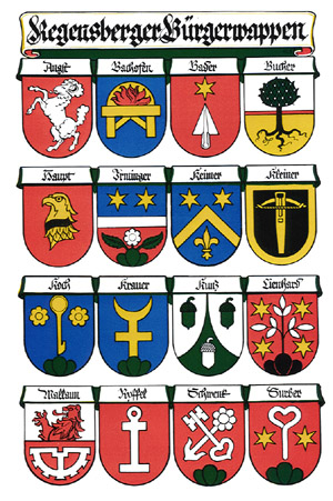
Picture #5 - Color version of the crests. Hedinger's book pg. 192 describes the Surber crest as " Dreiberg, Kehrnagel und Sterne nach Otelfingen Getreidesack aus 1850" (three hills or a 3-pointed hill, a bent or curved nail and stars in the style of a grain sack from Otelfingen from 1850. ) This translation comes from the innkeeper where we stayed in Grindelwald and from our son's high school German teacher in Indianapolis. Kehr refers to a loop or sharp turn. This raises the possibility that the family was in the hardware business, working wth iron. It also probably means that this has been the family crest only since 1850. Perhaps someone else can shed light on this. Otelfingen (about 5 kilometers southwest of Regensberg) is the birthplace of Regula Von Ruthi (1631-abt.1682) who married Hans Surber (1624-1679). The three hills could represent any three hills in the area.
Picture #6
Picture #6 - These buildings have signs dating them before 1735.
Pictures #7 and 8
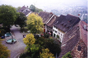
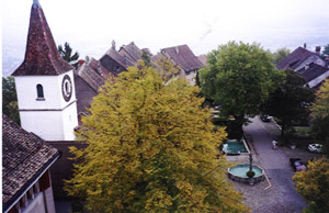
Pictures #7 and #8 - Regensberg is shaped much
like a football with one street running about the length of two
city blocks from the tower at one end to the cemetery at the
other end.. These photos taken from atop the tower show the south
and north sides of the street respectively. There is a gate at
each end of this "fortified city."
On p. 96 of his book, Hedinger lists the homeowners along the street at some time in the 1700s.. The second house past the church on the left is listed as belonging to "Frau Surber (Metzger Laba)." That means Mrs. Surber, who is the daughter of Mr. Laba, the butcher. Or it means Mrs. Surber who bought the home from Mr. Laba, the butcher. This is unclear from the German form used, but the first understanding is the more likely one. See endnote A below for more information on Butcher Laba who became Mayor.